Soil salinity is measured by its electrical conductivity. The SI unit of electrical conductivity (EC) is dS/m. Table 4 shows the relationship to other units of conductivity, and to NaCl concentration (10 mM NaCl has an EC close to 1 dS/m). Originally the conductivity was measured in a saturated paste extract (ECe), but the method is tedious as first the saturated paste has to be made, second the water needs to be extracted by a powerful vacuum pump, and third a very sandy soil does not make a saturated paste. A more convenient and universal method is a ‘1:5 extract’. The soil is dried or compressed, shaken with 5 g deionised water per 1 g soil, the probe of a hand-held conductivity meter is placed in the suspension, and the EC measured. The EC of the soil that was sampled can be calculated if its water content is known at the time of sampling. Alternatively, the measurement can be related to the field capacity of the soil using conversion factors. As a rough guide, a sandy soil will have a field capacity of 0.2 g water per g soil, and a clay soil about 0.4 g/g.
Table 4: Units for measuring salinity, and conversion factors. | |||
Conversion factors relating total dissolved salts or pure NaCl to an electrical conductivity (EC) of 1 dS/m (1 deciSiemen/metre) are given, along with equivalent units of various types, old and new. The conversion of EC of 1 dS/m to total dissovled salts (640 mg/L) assumes a composition of salts that is common in groundwater across the world. The exact factor varies from 530 (if the salt is predominantly NaCl) to 900 (if the salts are formed predominantly from divalent ions). | |||
Measurement and units | Application | 1 dS/m is equal to: | Equivalent units |
Conductivity (dS/m) | soils | 1 | 1 dS/m = 1 mS/cm = 1 mmho/cm |
Conductivity (µS/cm) | irrigation and river water | 1000 µS/cm | 1 µS/cm = 1 µmho/cm |
Total dissolved salts (mg/L) | irrigation and river water | 640 mg/L (approx.) | 1 mg/L = 1 mg/kg = 1 ppm |
Molarity of NaCl (mM) | laboratory | 10 mM | 1 mM = 1 mmol/L |
Table 5: Electrical conductivity (EC) of pure solutions at 20°C (dS/m). | |
The solutions represent those of salts found in soils or in seawater. Data from the Handbook of Physics and Chemistry (CRC Press, 55th editition, 1975). (Note that 1 dS/m = 1 mmho/cm).
| |
Solution | EC (dS/m) |
10 mM NaCl | 1.0 |
100 mM NaCl | 9.8 |
500 mM NaCl | 42.2 |
10 mM KCl | 1.2 |
10 mM CaCl2 | 1.8 |
10 mM MgCl2 | 1.6 |
50 mM MgCl2 | 8.1 |
The electrical conductivity of irrigation or river water is measured with the same hand-held conductivity meter as above, but is expressed in units 1000 times magnified, as channel or river water would normally have a very low concentration of salts. River water quality is often expressed as dS/cm (1000 x dS/m). Irrigation water quality is often expressed as total soluble salts, an international convention being that 1 dS/m is equivalent to 640 mg/L of mixed salts (Table 4).
Some data on the electrical conductivity of pure solutions relevant to saline soils or to seawater are given in Table 5. As 10 mM NaCl has an EC of almost exactly 1.0 dS/m, and as it is the most common salt in solution in ground or river water, a ‘rule of thumb’ is to muliply the EC by ten to equate it to salt molarity.
Soil salinity on a large scale is mapped with an electromagnetic (EM) conductivity meter. This instrument estimates the bulk electrical conductivity of the soil, which depends on the salinity of the soil solution, its water content, and the type and amount of clay in the soil. The output needs to be calibrated by chemical measurements of cores taken from the field. The ground EM conductivity meters consist of a small transmitter coil, energised with an alternative current. This current generates a primary magnetic field in the ground, which induces small currents which generate their own secondary magnetic field, which is smaller and proportional to the soil conductivity. A receiver coil close by measures the primary and secondary magnetic fields. The EM38 meter (Geonics Limited) is designed for agricultural surveys and measures to 1.5 m depth in the vertical mode and 0.75 m in the horizontal mode. An EM38 survey can be used to map the extent of subsoil salinity as well as discharge areas. Fig 1 illustrates the heterogeneity of soil salinity as shown by the EM meter.
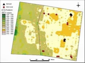
Figure 1. Example of an EM survey taken on a paddock basis at ground level. (Image courtesy of P. Rampant, Department of Primary Industry, Bendigo, Australia).
Airborne EM mapping is feasible now that global positioning systems have become available for accurate and rapid mapping. In the airborne method, the transmitter is slung below a plane flying at 150 m, and the receiver is towed behind. The plane generates a magnetic field, and the moving field passsing through the ground creates a secondary electric field whenever it hits something conductive. The receiver trailing behind the plane collects the data (For example, the Australian National Airborne Physics Project).